In order to serve my country's hydrology cause, the wide-ranging rainfall test can be automatically measured, automatically stored, and the year-end data can be compiled by the computer, and a hydrological database can be established. According to the actual needs of each hydrological station, our company has developed a fully automatic rainfall and water level telemetry system.
The automatic rainfall water level telemetry system has reasonable design, accurate counting, reliable storage, beautiful appearance, convenient operation and use, and can set various parameters and receive data (real-time rainfall, whole point rainfall, etc.) through the background computer. The battery adopts rechargeable batteries with large capacity and high reliability.
DataPlatform is equipped with special data processing software, which can be directly installed under win7/windows xp/98/2000. It is simple to use, easy to operate, intuitive man-machine dialogue, easy to learn and understand, and fast in processing rainfall data. The printed rainfall year-end reorganization table complies with the regulations of the Hydrological Yearbook.
The automatic rainfall water level telemetry system is mainly composed of four parts:
1) Data monitoring center;
2) Wireless data transmission communication platform;
3) Telemetry end point machine: various types of measurement and control end points to meet different power supply and installation environments.
4) Various sensors such as rainfall and water level.
The overall design diagram, as shown in the figure:
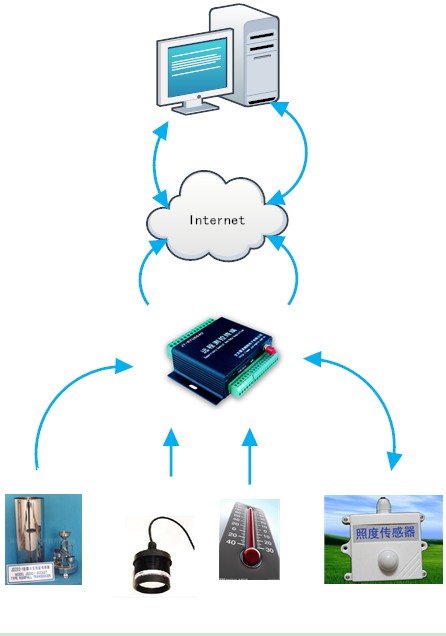
Design drawing of automatic rainfall and water level telemetry system
The communication of this system mainly adopts the GPRS method. With the help of the mobile company's GPRS network platform to transmit data, as long as there is a GPRS signal, wireless transmission can be performed. For places where the GPRS signal is not strong, short message communication can also be used. In the monitoring center configuration server, install the automatic rainfall and water level telemetry system monitoring and management system software; install telemetry end point machines at each monitoring point to monitor wind direction, wind speed, temperature, humidity, dew point, air pressure, rainfall, solar radiation, photosynthetically active radiation and other data, end point machine configuration a data card (can be handled at the local mobile company), transmit the monitoring data to the monitoring center through the GPRS network platform, and display it on the software interface.
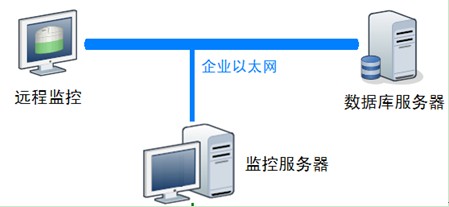
2. Hardware equipment
2.1 Server
2.2 Printer
2.3 Wireless transmission equipment
GPRS wireless data transmitter referred to as GPRS wireless data transmission end point
Function description: It is used to transmit data with the monitoring end point, collect and organize the data, and use it for remote maintenance and control of the end point equipment.
2.4 Wireless data transmission communication platform
The topology is as follows:
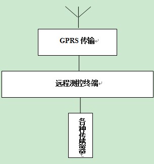
The parameters collected by various types of transmitters are wirelessly transmitted to the Internet by the RTU remote measurement and control end point through the GPRS network, and then received by the server.
3. Remote measurement and control end point
A variety of remote measurement and control end points to meet different working environments and customer needs;
4. Sensors
4.1. Rainfall sensor
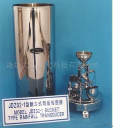
This scheme adopts a tipping bucket rain gauge. The tipping bucket rain gauge is a telemetry rainfall instrument composed of a sensor and a signal recorder. The sensor is composed of a water carrier, an upper tipping bucket, a measuring tipping bucket, a counting tipping bucket, a dry spring switch, etc.; the recorder is composed of a counter, a recording pen, a self-recording clock, a control circuit board, etc. Its working principle is as follows: rainwater enters the water receiver from the uppermost water receiving port, falls into the water receiving funnel, and flows into the tipping bucket through the funnel mouth. When the amount of water accumulation reaches a certain height (such as 0.1 mm), the tipping bucket loses its balance and overturns. And every time the tipping bucket is dumped, the switch is turned on to the circuit, and a pulse signal is sent to the recorder. The recorder controls the self-stylus to record the rainfall, so that the rainfall process can be measured back and forth.
Sensor physical map:
4.2. Water level gauge
The water level gauge mainly includes float type water level gauge, radar type water level gauge, bubble type water level gauge, ultrasonic water level gauge and so on.
This scheme adopts ultrasonic water level meter. Ultrasonic water level meter is suitable for water level measurement in rivers, lakes, reservoirs, estuaries, channels, ship locks and various hydraulic buildings. Therefore, it can be used as a sensor for water level data collection systems and hydrological automatic forecasting systems.
Features
1) Non-contact measurement, free from water pollution, no damage to the water flow structure
2) No need to build logging, saving civil investment
3) No touchpoint switch components
4) Flanged or threaded connection for easy installation
5) No mechanical wear, stable and durable
6) The power supply and output signal use the same two-core cable
7) Automatic temperature compensation and pressure correction
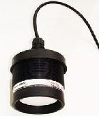
超声波水位计
Features:
1. Measure the instantaneous rainfall and total rainfall in real time, collect data and upload it to the control center. Two working modes can be adopted, AC power supply, solar panel power supply, and the second is usually standby and dormant. When the rainfall reaches a certain value, wake up the RTU or send an instruction from the control center to start the end point.
2. While collecting rainfall data, other sensors can also be installed according to different needs, such as temperature sensors, lighting sensors, etc.;
3. Use GPRS wireless data transmission end point to send data, as long as there is a mobile phone signal, it can work;
4. The end point RTU can also provide some special customized functions according to customer needs, such as supplying power to the outside through the AD port.
1. Monitoring center system equipment list
| Serial number | Device name |
| 1 | Server (4-core Intel Xeon 3.0GHz × 2/DDR2 memory 4GB/hot-swappable SAS hard drive 3 * 300G, 10,000/SAS RAID card/DVD/dual Gigabit Ethernet interface/power supply quantity 2) |
| 2 | Printer (black and white laser A3) |
| 3 | Operating system software (genuine) |
| 4 | Database (genuine) |
| 5 | Firewall software |
| 6 | RTU remote measurement and control end point |
| 7 | Remote monitoring system software |
| 8 | SIM data card |
2. List of sub-station equipment of automatic rainfall and water level telemetry system
| Serial number | Device name |
| 1 | Water level sensor |
| 2 | Rainfall sensor |
| 3 | Water level telemetry end point machine |
| 4 | Accumulator battery |
| 5 | Solar panels and brackets |
| 6 | Tipping bucket rain gauge station base |
| 7 | GPRS module |
| 8 | SIM data card |
Technical parameters:
Measuring range: 0~ 4mm/min (can work normally under the condition of < 8mm/min)
Measurement error: ± 3% (test rain intensity 2mm/min)
Min, discrimination rate: 0.2mm
Operating temperature: 0~ 80 ℃ (sensor) -40~ 80 ℃ (recorder)
Water bearing diameter: φ200mm + 0.6mm outer edge angle 45 degrees
Supply voltage: 12~ 24V DC
Accuracy: ± 1m/s
Starting wind: 0.2 m/s
Quantity range: 0~ 60 m/s
Measurement parameters
Range: 0~ 360 ° (divided into 16 fixed wind direction values, where "north" is marked by the arrow mark on the sensor)
Voltage signal: 0.4~ 2.0 V (fluctuation range ± 40mV)
Current signal: 4~ 20 mA (fluctuation range ± 0.4mA)
Conversion formula: wind direction typical value = (I -4)/1.06666 voltage type = (V -0.4)/ 0.106666
The corresponding table of the voltage type is as follows: (When in use, the wind direction value can be obtained by the look-up table method or direct operation)
North, North-Northeast, Northeast, East-Northeast
400 ± 40mV 50 ± 40mV 613 ± 40mV 720 ± 40mV
East, east-southeast, southeast, south-southeast
826 ± 40mV 933 ± 40mV 1040 ± 40mV 1146 ± 40mV
South, South by Southwest "Southwest, West by Southwest
1253 ± 40mV 1360 ± 40mV 1466 ± 40mV 1573 ± 40mV
West, west-northwest, northwest, north-northwest
1680 ± 40mV 1786 ± 40mV 1893 ± 40mV 2000 ± 40mV
The current type 4-19ma represents 16 directions, increasing by 1ma in sequence
Note: This program is copyrighted by Beijing Juying Soaring Electronics Co., Ltd. Reprinting is prohibited.

 Manager Wang
 OfficialAccounts